Cooperating Partners
Lower Loup 2016 . Upper Elkhorn (Bazile) . Twin Platte . Central Platte . Flight Map Files
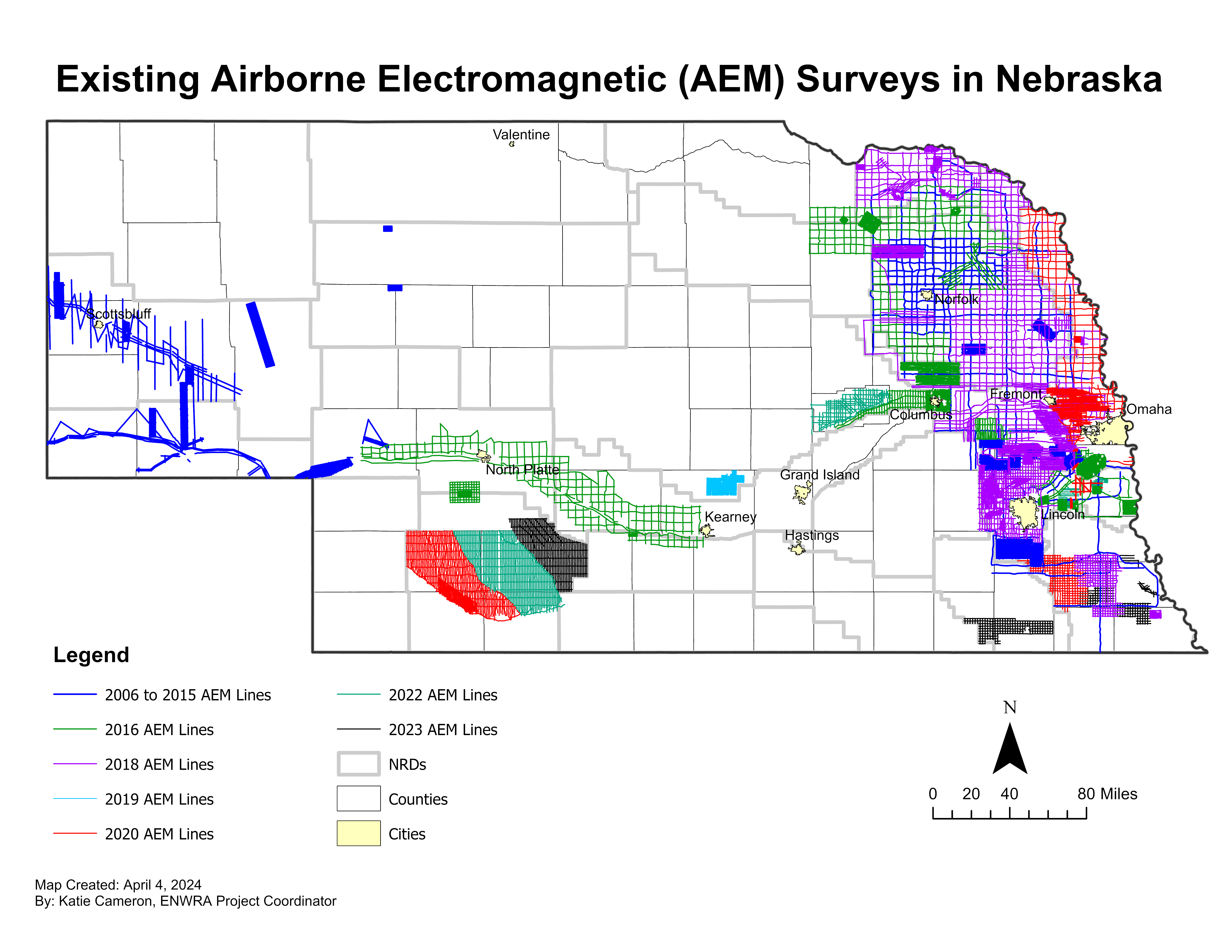
ENWRA often works with various cooperating agencies and partners across the state who have similar hydrogeologic assessment goals. This tab of the website summarizes project data for several cooperating Natural Resources Districts (NRDs) west of the ENWRA area who also conducted AEM flights using Water Sustainability Fund (WSF) grant dollars ("https://nrc.nebraska.gov/water-sustainability-fund-0").
![]() The AEM data for the cooperating partners are now availiable at the Nebraska GeoCloud (NGC): "https://snr.unl.edu/csd/geology/nebraskageocloud.aspx"). The NGC is a web-based digital platform for geophysical, geological, and groundwater data and models. The purpose of the NGC is to archive Nebraska’s vast volume of data and make it accessible to both model builders and model users.
The AEM data for the cooperating partners are now availiable at the Nebraska GeoCloud (NGC): "https://snr.unl.edu/csd/geology/nebraskageocloud.aspx"). The NGC is a web-based digital platform for geophysical, geological, and groundwater data and models. The purpose of the NGC is to archive Nebraska’s vast volume of data and make it accessible to both model builders and model users.
Additionally, the Lower Platte North NRD provided AEM data obtained for the Mead, Nebraska area by the U.S. Army Corps of Engineers (USACE) in 2012. Click here for a link to the reports.

Lower Loup NRD 2016 AEM Results (See LLNRD for 2019 AEM Results)Documents:
Hydrogeologic Framework of Selected Areas in
Lower Loup Natural Resources District,
Nebraska

 Report Text (PDF from Dropbox - you can select "no thanks" to the sign-up for a Dropbox account and still download the files, 33 MB)
Appendix_1_LLNRD_Area28_Reconnaissance_2D_Profiles (PDFs from Dropbox, 28.4 MB)
Appendix_1_LLNRD_Columbus_Block_2D_Profiles (PDFs from Dropbox, 66.3 MB)
Appendix_2_3D_Fence_Diagram_Area28_Reconnaissance (PDFs from Dropbox, 1.3 MB)
Appendix_2_3D_Fence_Diagram_Columbus Block (PDFs from Dropbox, 2 MB)
Google Earth Datasets:
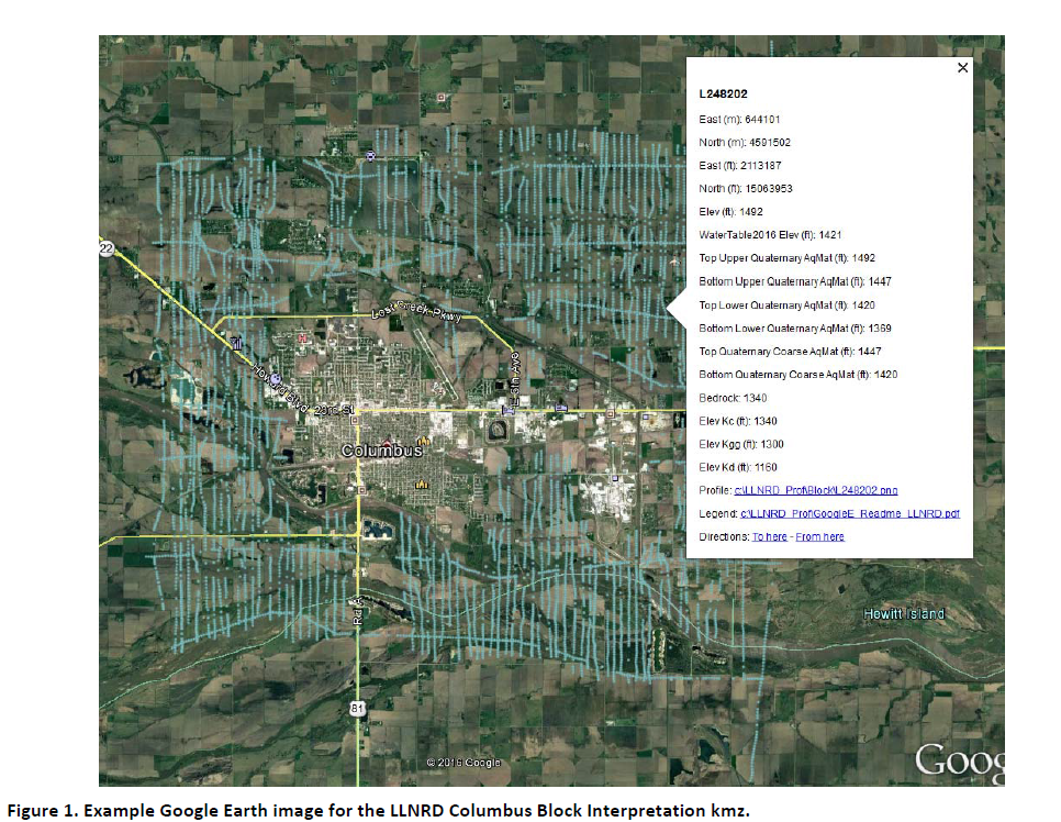
The interpreted results for the 2016 AEM flights have been provided in Google Earth format. You can download the free version of Google Earth Pro by clicking here. Click here for a link to download the Google Earth datasets (54 MB: recon .kmz file with 40 images and Columbus.kmz file with 76 images) from ENWRA's Dropbox. You can select "no thanks" to the sign-up for a Dropbox account and still download the files.
You must have Google Earth installed on your computer before downloading or opening the .kmz Google Earth dataset files.
If you already have a dropbox account, please choose direct download to your computer so you do not fill up space on your personal dropbox.
Please follow the instructions in the GoogleE_README_LLNRD.pdf Legend file on Dropbox here AND save the downloaded files with the same exact file structure as shown on the dropbox (including the main folder entitled LLNRD_Prof). Google Earth will look here on your hard drive: C:\LLNRD_Prof\ for every profile image when you touch a link on a data dot in Google Earth - see example image below. The files on your C drive must all be unzipped in order to work from Google Earth. For example: you can create a folder called "LLNRD_Prof" directly on your C drive, unzip the files wherever your browser typically saves downloaded files, and then save the unzipped downloaded files to that LLNRD_Prof folder on your C.
 Google Earth Tips and Tricks:
Grab the map with your cursor and hold down the "u" key on your keyboard to view the earth looking straight down instead of at an angle. Do the same and hit the "n" key to orient the map north as up.
Google Earth Pro (link above) is free and you can hit the file menu, then hit open, and then select all data import formats from the dropdown and open an ESRI shapefile or many other GIS file types in Google Earth directly from a saved location on your computer.
Google Earth Tips and Tricks:
Grab the map with your cursor and hold down the "u" key on your keyboard to view the earth looking straight down instead of at an angle. Do the same and hit the "n" key to orient the map north as up.
Google Earth Pro (link above) is free and you can hit the file menu, then hit open, and then select all data import formats from the dropdown and open an ESRI shapefile or many other GIS file types in Google Earth directly from a saved location on your computer.
Bazile Groundwater Management Area (BGMA)Documents:
Mapping the Hydrogeology of the Bazile Groundwater Management Area with Airborne Electromagnetics Surveys
Report Text (PDF from Dropbox - you can select "no thanks" to the sign-up for a Dropbox account and still download the files, 47 MB)
Appendix 1 - Appendix 13 (PDFs from Dropbox, 120 MB)
Google Earth Datasets:
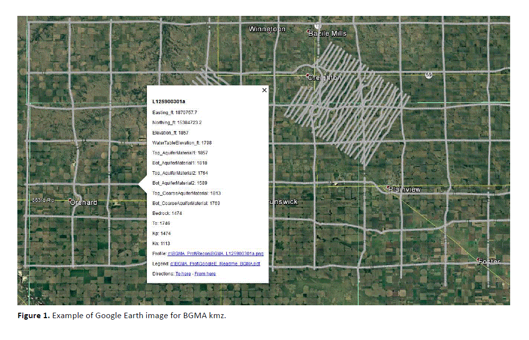
The interpreted results for the 2016 AEM flights have been provided in Google Earth format. You can download the free version of Google Earth Pro by clicking here. Click here for a link to download the Google Earth datasets (.kmz files) from ENWRA's Dropbox (you can select "no thanks" to the sign-up for a Dropbox account and still download the files).
You must have Google Earth installed on your computer before downloading or opening the .kmz Google Earth dataset files.
If you already have a dropbox account, please choose direct download to your computer so you do not fill up space on your personal dropbox.
Please follow the instructions in the GoogleE_README_BGMA.pdf file on Dropbox here AND save the downloaded files with the same exact file structure as shown on the dropbox (including the main folder entitled BGMA_Prof). Google Earth will look here on your hard drive: C:\BGMA_Prof\ for every profile image when you touch a link on a data dot in Google Earth - see example image below). The files on your C drive must all be unzipped in order to work from Google Earth.
 Google Earth Tips and Tricks:
Grab the map with your cursor and hold down the "u" key on your keyboard to view the earth looking straight down instead of at an angle. Do the same and hit the "n" key to orient the map north as up.
Google Earth Pro (link above) is free and you can hit the file menu, then hit open, and then select all data import formats from the dropdown and open an ESRI shapefile or many other GIS file types in Google Earth directly from a saved location on your computer.
Google Earth Tips and Tricks:
Grab the map with your cursor and hold down the "u" key on your keyboard to view the earth looking straight down instead of at an angle. Do the same and hit the "n" key to orient the map north as up.
Google Earth Pro (link above) is free and you can hit the file menu, then hit open, and then select all data import formats from the dropdown and open an ESRI shapefile or many other GIS file types in Google Earth directly from a saved location on your computer.


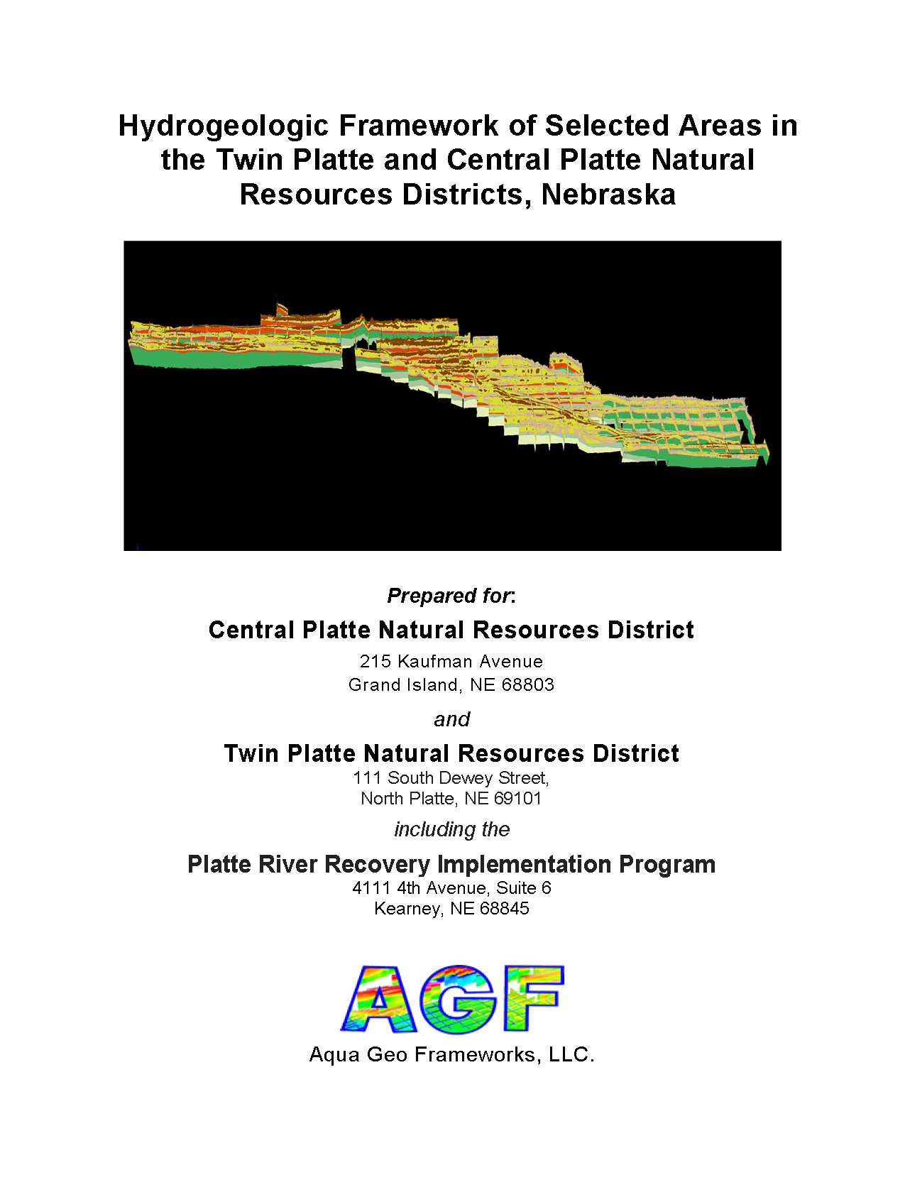
Twin Platte and Central Platte NRD 2016 AEM Results Documents:
Hydrogeologic Framework of Selected Areas in
The Twin Platte and Central Platte Natural Resources Districts,
Nebraska
Report Text (PDF from Dropbox - you can select "no thanks" to the sign-up for a Dropbox account and still download the files, 32 MB)
CPNRD Appendix 1: 2D Profiles
with Resistivity and Aquifer Interpretation (PDFs from Dropbox, 16.5 MB)
CPNRD Appendix 1: 2D Profiles
with Resistivity and Aquifer Interpretation - Fixed Scale (PDFs from Dropbox, 16.2 MB)
TPNRD Appendix 1: 2D Profiles
with Resistivity and Aquifer Interpretation (PDFs from Dropbox, 17.8 MB)
TPNRD Appendix 1: 2D Profiles
with Resistivity and Aquifer Interpretation - Fixed Scale (PDFs from Dropbox, 17.4 MB)
PRRIP Appendix 1: 2D Profiles with Resistivity and Aquifer
Interpretation (PDFs from Dropbox, 4.3 MB)
N-CORPE Appendix 1: 2D Profiles with Resistivity and Aquifer
Interpretation (PDFs from Dropbox, 9.5 MB)
Appendix_2_2D Surfaces - CPNRD, TPNRD, CPNRD/TPNRD, PRRIP, N-CORPE (PDFs from Dropbox, 40 MB)
Appendix_2_3D Fences - CPNRD/TPNRD/PRRIP, CPNRD/PRRIP, TPNRD, PRRIP, N-CORPE (PDFs from Dropbox, 14 MB)
Appendix_2_3D Voxels - N-CORPE and PRRIP Blocks (PDFs from Dropbox, 4.6 MB)
Google Earth Datasets:
The interpreted results for the 2016 AEM flights have been provided in Google Earth format. You can download the free version of Google Earth Pro by clicking here.
Click here for a link to download the CPNRD Google Earth datasets (53 MB: .kmz file with 90 images) from ENWRA's Dropbox.
Click here for a link to download the TPNRD Google Earth datasets (45 MB: .kmz file with 78 images) from ENWRA's Dropbox.
Click here for a link to download the PRRIP Google Earth datasets (10 MB: .kmz file with 17 images) from ENWRA's Dropbox.
Click here for a link to download the N-CORPE Google Earth datasets (15 MB: .kmz file with 30 images) from ENWRA's Dropbox.
You can select "no thanks" to the sign-up for a Dropbox account and still download the files.
You must have Google Earth installed on your computer before downloading or opening the .kmz Google Earth dataset files.
If you already have a dropbox account, please choose direct download to your computer so you do not fill up space on your personal dropbox.
Please follow the instructions in the GoogleE_CP_README.pdf, GoogleE_TP_README.pdf, GoogleE_PR_README.pdf, and GoogleE_N_README.pdf legend files on Dropbox here, here, here, and here (respectively) AND save the downloaded files with the same exact file structure as shown on the dropbox. Google Earth will look here on your hard drive: C:\CPNRD_Profiles\ (flights within CPNRD), C:\TPNRD_Profiles\ (flights within TPNRD), C:\PRRIP_Profiles\ (flights within PRRIP area), OR C:\NCORPE_Profiles\ (flights within N-CORPE area) for every profile image when you touch a link on a data dot in Google Earth - see example image below. The files on your C drive must all be unzipped in order to work from Google Earth. For example: you can create a folder called "CPNRD_Profiles" directly on your C drive, unzip the files wherever your browser typically saves downloaded files, and then save the unzipped downloaded files to that "CPNRD_Profiles" folder on your C.
 Google Earth Tips and Tricks:
Grab the map with your cursor and hold down the "u" key on your keyboard to view the earth looking straight down instead of at an angle. Do the same and hit the "n" key to orient the map north as up.
Google Earth Pro (link above) is free and you can hit the file menu, then hit open, and then select all data import formats from the dropdown and open an ESRI shapefile or many other GIS file types in Google Earth directly from a saved location on your computer.
Google Earth Tips and Tricks:
Grab the map with your cursor and hold down the "u" key on your keyboard to view the earth looking straight down instead of at an angle. Do the same and hit the "n" key to orient the map north as up.
Google Earth Pro (link above) is free and you can hit the file menu, then hit open, and then select all data import formats from the dropdown and open an ESRI shapefile or many other GIS file types in Google Earth directly from a saved location on your computer.
Digital version of Flight Lines used in the map below:  Shapefile Download (5.4 MB)
  kmz file Download (5.2 MB)
![]()
Documents:
Hydrogeologic Framework of Selected Areas in Lower Loup Natural Resources District, Nebraska
![]() Report Text (PDF from Dropbox - you can select "no thanks" to the sign-up for a Dropbox account and still download the files, 33 MB)
Report Text (PDF from Dropbox - you can select "no thanks" to the sign-up for a Dropbox account and still download the files, 33 MB)
![]() Appendix_1_LLNRD_Area28_Reconnaissance_2D_Profiles (PDFs from Dropbox, 28.4 MB)
Appendix_1_LLNRD_Area28_Reconnaissance_2D_Profiles (PDFs from Dropbox, 28.4 MB)
![]() Appendix_1_LLNRD_Columbus_Block_2D_Profiles (PDFs from Dropbox, 66.3 MB)
Appendix_1_LLNRD_Columbus_Block_2D_Profiles (PDFs from Dropbox, 66.3 MB)
![]() Appendix_2_3D_Fence_Diagram_Area28_Reconnaissance (PDFs from Dropbox, 1.3 MB)
Appendix_2_3D_Fence_Diagram_Area28_Reconnaissance (PDFs from Dropbox, 1.3 MB)
![]() Appendix_2_3D_Fence_Diagram_Columbus Block (PDFs from Dropbox, 2 MB)
Appendix_2_3D_Fence_Diagram_Columbus Block (PDFs from Dropbox, 2 MB)
Google Earth Datasets:
The interpreted results for the 2016 AEM flights have been provided in Google Earth format. You can download the free version of Google Earth Pro by clicking here. Click here for a link to download the Google Earth datasets (54 MB: recon .kmz file with 40 images and Columbus.kmz file with 76 images) from ENWRA's Dropbox. You can select "no thanks" to the sign-up for a Dropbox account and still download the files. You must have Google Earth installed on your computer before downloading or opening the .kmz Google Earth dataset files.
If you already have a dropbox account, please choose direct download to your computer so you do not fill up space on your personal dropbox.
Please follow the instructions in the GoogleE_README_LLNRD.pdf Legend file on Dropbox here AND save the downloaded files with the same exact file structure as shown on the dropbox (including the main folder entitled LLNRD_Prof). Google Earth will look here on your hard drive: C:\LLNRD_Prof\ for every profile image when you touch a link on a data dot in Google Earth - see example image below. The files on your C drive must all be unzipped in order to work from Google Earth. For example: you can create a folder called "LLNRD_Prof" directly on your C drive, unzip the files wherever your browser typically saves downloaded files, and then save the unzipped downloaded files to that LLNRD_Prof folder on your C.
Google Earth Tips and Tricks:
Grab the map with your cursor and hold down the "u" key on your keyboard to view the earth looking straight down instead of at an angle. Do the same and hit the "n" key to orient the map north as up.
Google Earth Pro (link above) is free and you can hit the file menu, then hit open, and then select all data import formats from the dropdown and open an ESRI shapefile or many other GIS file types in Google Earth directly from a saved location on your computer.
Bazile Groundwater Management Area (BGMA)Documents:
Mapping the Hydrogeology of the Bazile Groundwater Management Area with Airborne Electromagnetics Surveys
Report Text (PDF from Dropbox - you can select "no thanks" to the sign-up for a Dropbox account and still download the files, 47 MB)
Appendix 1 - Appendix 13 (PDFs from Dropbox, 120 MB)
Google Earth Datasets:
The interpreted results for the 2016 AEM flights have been provided in Google Earth format. You can download the free version of Google Earth Pro by clicking here. Click here for a link to download the Google Earth datasets (.kmz files) from ENWRA's Dropbox (you can select "no thanks" to the sign-up for a Dropbox account and still download the files).
You must have Google Earth installed on your computer before downloading or opening the .kmz Google Earth dataset files.
If you already have a dropbox account, please choose direct download to your computer so you do not fill up space on your personal dropbox.
Please follow the instructions in the GoogleE_README_BGMA.pdf file on Dropbox here AND save the downloaded files with the same exact file structure as shown on the dropbox (including the main folder entitled BGMA_Prof). Google Earth will look here on your hard drive: C:\BGMA_Prof\ for every profile image when you touch a link on a data dot in Google Earth - see example image below). The files on your C drive must all be unzipped in order to work from Google Earth.
Google Earth Tips and Tricks:
Grab the map with your cursor and hold down the "u" key on your keyboard to view the earth looking straight down instead of at an angle. Do the same and hit the "n" key to orient the map north as up.
Google Earth Pro (link above) is free and you can hit the file menu, then hit open, and then select all data import formats from the dropdown and open an ESRI shapefile or many other GIS file types in Google Earth directly from a saved location on your computer.
Twin Platte and Central Platte NRD 2016 AEM Results Documents:
Hydrogeologic Framework of Selected Areas in
The Twin Platte and Central Platte Natural Resources Districts,
Nebraska
Report Text (PDF from Dropbox - you can select "no thanks" to the sign-up for a Dropbox account and still download the files, 32 MB)
CPNRD Appendix 1: 2D Profiles
with Resistivity and Aquifer Interpretation (PDFs from Dropbox, 16.5 MB)
CPNRD Appendix 1: 2D Profiles
with Resistivity and Aquifer Interpretation - Fixed Scale (PDFs from Dropbox, 16.2 MB)
TPNRD Appendix 1: 2D Profiles
with Resistivity and Aquifer Interpretation (PDFs from Dropbox, 17.8 MB)
TPNRD Appendix 1: 2D Profiles
with Resistivity and Aquifer Interpretation - Fixed Scale (PDFs from Dropbox, 17.4 MB)
PRRIP Appendix 1: 2D Profiles with Resistivity and Aquifer
Interpretation (PDFs from Dropbox, 4.3 MB)
N-CORPE Appendix 1: 2D Profiles with Resistivity and Aquifer
Interpretation (PDFs from Dropbox, 9.5 MB)
Appendix_2_2D Surfaces - CPNRD, TPNRD, CPNRD/TPNRD, PRRIP, N-CORPE (PDFs from Dropbox, 40 MB)
Appendix_2_3D Fences - CPNRD/TPNRD/PRRIP, CPNRD/PRRIP, TPNRD, PRRIP, N-CORPE (PDFs from Dropbox, 14 MB)
Appendix_2_3D Voxels - N-CORPE and PRRIP Blocks (PDFs from Dropbox, 4.6 MB)
Google Earth Datasets:
The interpreted results for the 2016 AEM flights have been provided in Google Earth format. You can download the free version of Google Earth Pro by clicking here.
Click here for a link to download the CPNRD Google Earth datasets (53 MB: .kmz file with 90 images) from ENWRA's Dropbox.
Click here for a link to download the TPNRD Google Earth datasets (45 MB: .kmz file with 78 images) from ENWRA's Dropbox.
Click here for a link to download the PRRIP Google Earth datasets (10 MB: .kmz file with 17 images) from ENWRA's Dropbox.
Click here for a link to download the N-CORPE Google Earth datasets (15 MB: .kmz file with 30 images) from ENWRA's Dropbox.
You can select "no thanks" to the sign-up for a Dropbox account and still download the files.
You must have Google Earth installed on your computer before downloading or opening the .kmz Google Earth dataset files.
If you already have a dropbox account, please choose direct download to your computer so you do not fill up space on your personal dropbox.
Please follow the instructions in the GoogleE_CP_README.pdf, GoogleE_TP_README.pdf, GoogleE_PR_README.pdf, and GoogleE_N_README.pdf legend files on Dropbox here, here, here, and here (respectively) AND save the downloaded files with the same exact file structure as shown on the dropbox. Google Earth will look here on your hard drive: C:\CPNRD_Profiles\ (flights within CPNRD), C:\TPNRD_Profiles\ (flights within TPNRD), C:\PRRIP_Profiles\ (flights within PRRIP area), OR C:\NCORPE_Profiles\ (flights within N-CORPE area) for every profile image when you touch a link on a data dot in Google Earth - see example image below. The files on your C drive must all be unzipped in order to work from Google Earth. For example: you can create a folder called "CPNRD_Profiles" directly on your C drive, unzip the files wherever your browser typically saves downloaded files, and then save the unzipped downloaded files to that "CPNRD_Profiles" folder on your C.
Google Earth Tips and Tricks:
Grab the map with your cursor and hold down the "u" key on your keyboard to view the earth looking straight down instead of at an angle. Do the same and hit the "n" key to orient the map north as up.
Google Earth Pro (link above) is free and you can hit the file menu, then hit open, and then select all data import formats from the dropdown and open an ESRI shapefile or many other GIS file types in Google Earth directly from a saved location on your computer.
Digital version of Flight Lines used in the map below: Shapefile Download (5.4 MB) kmz file Download (5.2 MB)
Documents:
Mapping the Hydrogeology of the Bazile Groundwater Management Area with Airborne Electromagnetics Surveys
![]() Report Text (PDF from Dropbox - you can select "no thanks" to the sign-up for a Dropbox account and still download the files, 47 MB)
Report Text (PDF from Dropbox - you can select "no thanks" to the sign-up for a Dropbox account and still download the files, 47 MB)
![]() Appendix 1 - Appendix 13 (PDFs from Dropbox, 120 MB)
Appendix 1 - Appendix 13 (PDFs from Dropbox, 120 MB)
Google Earth Datasets:
The interpreted results for the 2016 AEM flights have been provided in Google Earth format. You can download the free version of Google Earth Pro by clicking here. Click here for a link to download the Google Earth datasets (.kmz files) from ENWRA's Dropbox (you can select "no thanks" to the sign-up for a Dropbox account and still download the files). You must have Google Earth installed on your computer before downloading or opening the .kmz Google Earth dataset files.
If you already have a dropbox account, please choose direct download to your computer so you do not fill up space on your personal dropbox.
Please follow the instructions in the GoogleE_README_BGMA.pdf file on Dropbox here AND save the downloaded files with the same exact file structure as shown on the dropbox (including the main folder entitled BGMA_Prof). Google Earth will look here on your hard drive: C:\BGMA_Prof\ for every profile image when you touch a link on a data dot in Google Earth - see example image below). The files on your C drive must all be unzipped in order to work from Google Earth.
Google Earth Tips and Tricks:
Grab the map with your cursor and hold down the "u" key on your keyboard to view the earth looking straight down instead of at an angle. Do the same and hit the "n" key to orient the map north as up.
Google Earth Pro (link above) is free and you can hit the file menu, then hit open, and then select all data import formats from the dropdown and open an ESRI shapefile or many other GIS file types in Google Earth directly from a saved location on your computer.
Twin Platte and Central Platte NRD 2016 AEM Results Documents:
Hydrogeologic Framework of Selected Areas in
The Twin Platte and Central Platte Natural Resources Districts,
Nebraska
Report Text (PDF from Dropbox - you can select "no thanks" to the sign-up for a Dropbox account and still download the files, 32 MB)
CPNRD Appendix 1: 2D Profiles
with Resistivity and Aquifer Interpretation (PDFs from Dropbox, 16.5 MB)
CPNRD Appendix 1: 2D Profiles
with Resistivity and Aquifer Interpretation - Fixed Scale (PDFs from Dropbox, 16.2 MB)
TPNRD Appendix 1: 2D Profiles
with Resistivity and Aquifer Interpretation (PDFs from Dropbox, 17.8 MB)
TPNRD Appendix 1: 2D Profiles
with Resistivity and Aquifer Interpretation - Fixed Scale (PDFs from Dropbox, 17.4 MB)
PRRIP Appendix 1: 2D Profiles with Resistivity and Aquifer
Interpretation (PDFs from Dropbox, 4.3 MB)
N-CORPE Appendix 1: 2D Profiles with Resistivity and Aquifer
Interpretation (PDFs from Dropbox, 9.5 MB)
Appendix_2_2D Surfaces - CPNRD, TPNRD, CPNRD/TPNRD, PRRIP, N-CORPE (PDFs from Dropbox, 40 MB)
Appendix_2_3D Fences - CPNRD/TPNRD/PRRIP, CPNRD/PRRIP, TPNRD, PRRIP, N-CORPE (PDFs from Dropbox, 14 MB)
Appendix_2_3D Voxels - N-CORPE and PRRIP Blocks (PDFs from Dropbox, 4.6 MB)
Google Earth Datasets:
The interpreted results for the 2016 AEM flights have been provided in Google Earth format. You can download the free version of Google Earth Pro by clicking here.
Click here for a link to download the CPNRD Google Earth datasets (53 MB: .kmz file with 90 images) from ENWRA's Dropbox.
Click here for a link to download the TPNRD Google Earth datasets (45 MB: .kmz file with 78 images) from ENWRA's Dropbox.
Click here for a link to download the PRRIP Google Earth datasets (10 MB: .kmz file with 17 images) from ENWRA's Dropbox.
Click here for a link to download the N-CORPE Google Earth datasets (15 MB: .kmz file with 30 images) from ENWRA's Dropbox.
You can select "no thanks" to the sign-up for a Dropbox account and still download the files.
You must have Google Earth installed on your computer before downloading or opening the .kmz Google Earth dataset files.
If you already have a dropbox account, please choose direct download to your computer so you do not fill up space on your personal dropbox.
Please follow the instructions in the GoogleE_CP_README.pdf, GoogleE_TP_README.pdf, GoogleE_PR_README.pdf, and GoogleE_N_README.pdf legend files on Dropbox here, here, here, and here (respectively) AND save the downloaded files with the same exact file structure as shown on the dropbox. Google Earth will look here on your hard drive: C:\CPNRD_Profiles\ (flights within CPNRD), C:\TPNRD_Profiles\ (flights within TPNRD), C:\PRRIP_Profiles\ (flights within PRRIP area), OR C:\NCORPE_Profiles\ (flights within N-CORPE area) for every profile image when you touch a link on a data dot in Google Earth - see example image below. The files on your C drive must all be unzipped in order to work from Google Earth. For example: you can create a folder called "CPNRD_Profiles" directly on your C drive, unzip the files wherever your browser typically saves downloaded files, and then save the unzipped downloaded files to that "CPNRD_Profiles" folder on your C.
Google Earth Tips and Tricks:
Grab the map with your cursor and hold down the "u" key on your keyboard to view the earth looking straight down instead of at an angle. Do the same and hit the "n" key to orient the map north as up.
Google Earth Pro (link above) is free and you can hit the file menu, then hit open, and then select all data import formats from the dropdown and open an ESRI shapefile or many other GIS file types in Google Earth directly from a saved location on your computer.
Digital version of Flight Lines used in the map below: Shapefile Download (5.4 MB) kmz file Download (5.2 MB)
![]()
![]()
Documents:
Hydrogeologic Framework of Selected Areas in The Twin Platte and Central Platte Natural Resources Districts, Nebraska
![]() Report Text (PDF from Dropbox - you can select "no thanks" to the sign-up for a Dropbox account and still download the files, 32 MB)
Report Text (PDF from Dropbox - you can select "no thanks" to the sign-up for a Dropbox account and still download the files, 32 MB)
![]() CPNRD Appendix 1: 2D Profiles
with Resistivity and Aquifer Interpretation (PDFs from Dropbox, 16.5 MB)
CPNRD Appendix 1: 2D Profiles
with Resistivity and Aquifer Interpretation (PDFs from Dropbox, 16.5 MB)
![]() CPNRD Appendix 1: 2D Profiles
with Resistivity and Aquifer Interpretation - Fixed Scale (PDFs from Dropbox, 16.2 MB)
CPNRD Appendix 1: 2D Profiles
with Resistivity and Aquifer Interpretation - Fixed Scale (PDFs from Dropbox, 16.2 MB)
![]() TPNRD Appendix 1: 2D Profiles
with Resistivity and Aquifer Interpretation (PDFs from Dropbox, 17.8 MB)
TPNRD Appendix 1: 2D Profiles
with Resistivity and Aquifer Interpretation (PDFs from Dropbox, 17.8 MB)
![]() TPNRD Appendix 1: 2D Profiles
with Resistivity and Aquifer Interpretation - Fixed Scale (PDFs from Dropbox, 17.4 MB)
TPNRD Appendix 1: 2D Profiles
with Resistivity and Aquifer Interpretation - Fixed Scale (PDFs from Dropbox, 17.4 MB)
![]() PRRIP Appendix 1: 2D Profiles with Resistivity and Aquifer
Interpretation (PDFs from Dropbox, 4.3 MB)
PRRIP Appendix 1: 2D Profiles with Resistivity and Aquifer
Interpretation (PDFs from Dropbox, 4.3 MB)
![]() N-CORPE Appendix 1: 2D Profiles with Resistivity and Aquifer
Interpretation (PDFs from Dropbox, 9.5 MB)
N-CORPE Appendix 1: 2D Profiles with Resistivity and Aquifer
Interpretation (PDFs from Dropbox, 9.5 MB)
![]() Appendix_2_2D Surfaces - CPNRD, TPNRD, CPNRD/TPNRD, PRRIP, N-CORPE (PDFs from Dropbox, 40 MB)
Appendix_2_2D Surfaces - CPNRD, TPNRD, CPNRD/TPNRD, PRRIP, N-CORPE (PDFs from Dropbox, 40 MB)
![]() Appendix_2_3D Fences - CPNRD/TPNRD/PRRIP, CPNRD/PRRIP, TPNRD, PRRIP, N-CORPE (PDFs from Dropbox, 14 MB)
Appendix_2_3D Fences - CPNRD/TPNRD/PRRIP, CPNRD/PRRIP, TPNRD, PRRIP, N-CORPE (PDFs from Dropbox, 14 MB)
![]() Appendix_2_3D Voxels - N-CORPE and PRRIP Blocks (PDFs from Dropbox, 4.6 MB)
Appendix_2_3D Voxels - N-CORPE and PRRIP Blocks (PDFs from Dropbox, 4.6 MB)
Google Earth Datasets:
The interpreted results for the 2016 AEM flights have been provided in Google Earth format. You can download the free version of Google Earth Pro by clicking here.
Click here for a link to download the CPNRD Google Earth datasets (53 MB: .kmz file with 90 images) from ENWRA's Dropbox.
Click here for a link to download the TPNRD Google Earth datasets (45 MB: .kmz file with 78 images) from ENWRA's Dropbox.
Click here for a link to download the PRRIP Google Earth datasets (10 MB: .kmz file with 17 images) from ENWRA's Dropbox.
Click here for a link to download the N-CORPE Google Earth datasets (15 MB: .kmz file with 30 images) from ENWRA's Dropbox.
You can select "no thanks" to the sign-up for a Dropbox account and still download the files. You must have Google Earth installed on your computer before downloading or opening the .kmz Google Earth dataset files.
If you already have a dropbox account, please choose direct download to your computer so you do not fill up space on your personal dropbox.
Please follow the instructions in the GoogleE_CP_README.pdf, GoogleE_TP_README.pdf, GoogleE_PR_README.pdf, and GoogleE_N_README.pdf legend files on Dropbox here, here, here, and here (respectively) AND save the downloaded files with the same exact file structure as shown on the dropbox. Google Earth will look here on your hard drive: C:\CPNRD_Profiles\ (flights within CPNRD), C:\TPNRD_Profiles\ (flights within TPNRD), C:\PRRIP_Profiles\ (flights within PRRIP area), OR C:\NCORPE_Profiles\ (flights within N-CORPE area) for every profile image when you touch a link on a data dot in Google Earth - see example image below. The files on your C drive must all be unzipped in order to work from Google Earth. For example: you can create a folder called "CPNRD_Profiles" directly on your C drive, unzip the files wherever your browser typically saves downloaded files, and then save the unzipped downloaded files to that "CPNRD_Profiles" folder on your C.
Google Earth Tips and Tricks:
Grab the map with your cursor and hold down the "u" key on your keyboard to view the earth looking straight down instead of at an angle. Do the same and hit the "n" key to orient the map north as up.
Google Earth Pro (link above) is free and you can hit the file menu, then hit open, and then select all data import formats from the dropdown and open an ESRI shapefile or many other GIS file types in Google Earth directly from a saved location on your computer.
Digital version of Flight Lines used in the map below: Shapefile Download (5.4 MB) kmz file Download (5.2 MB)
Digital version of Flight Lines used in the map below: ![]() Shapefile Download (5.4 MB)
Shapefile Download (5.4 MB) ![]() kmz file Download (5.2 MB)
kmz file Download (5.2 MB)