2015 Airborne Electromagnetic Survey (AEM) Reports
Documents
2014 FLIGHTS REPORT VOLUME I: Final Report on Airborne Electromagnetic Geophysical Surveys and Hydrogeologic Framework Development for the Eastern Nebraska Water Resources Assessment – Volume I, including the Lewis and Clark, Lower Elkhorn, and Papio- Missouri River Natural Resources Districts
![]() Report Text (PDF, 18.4 MB)
Report Text (PDF, 18.4 MB)
![]() Appendix 1 (PDF, 40.9 MB)
Appendix 1 (PDF, 40.9 MB)
![]() Appendix 2 (PDF, 19.4 MB)
Appendix 2 (PDF, 19.4 MB)
![]() Appendix 3 (PDF, 3.3 MB)
Appendix 3 (PDF, 3.3 MB)
![]() Appendix 4 (updated 9/24/15) (ZIP, 366 MB)
Appendix 4 (updated 9/24/15) (ZIP, 366 MB)
![]() Appendix 5 (PDF, 688 KB)
Appendix 5 (PDF, 688 KB)
![]() Appendix 5 Data Table (XLSX, 117 KB)
Appendix 5 Data Table (XLSX, 117 KB)
2015 FLIGHTS REPORT VOLUME II: Final Report on Airborne Electromagnetic Geophysical Surveys and Hydrogeologic Framework Development for the Eastern Nebraska Water Resources Assessment – Volume 2, including the Lower Platte North, Lower Platte South, and Nemaha Natural Resources Districts
![]() Report Text (PDF, 13.4 MB)
Report Text (PDF, 13.4 MB)
![]() Appendix 1 (PDF, 48.1 MB)
Appendix 1 (PDF, 48.1 MB)
![]() Appendix 2 (PDF, 15.3 MB)
Appendix 2 (PDF, 15.3 MB)
![]() Appendix 3 (PDF, 3.3 MB)
Appendix 3 (PDF, 3.3 MB)
![]() Appendix 4(updated 9/24/15) (ZIP, 70 MB)
Appendix 4(updated 9/24/15) (ZIP, 70 MB)
![]() Appendix 5 (PDF, 204 KB)
Appendix 5 (PDF, 204 KB)
![]() Appendix 5 Data Table (XLSX, 237 KB)
Appendix 5 Data Table (XLSX, 237 KB)
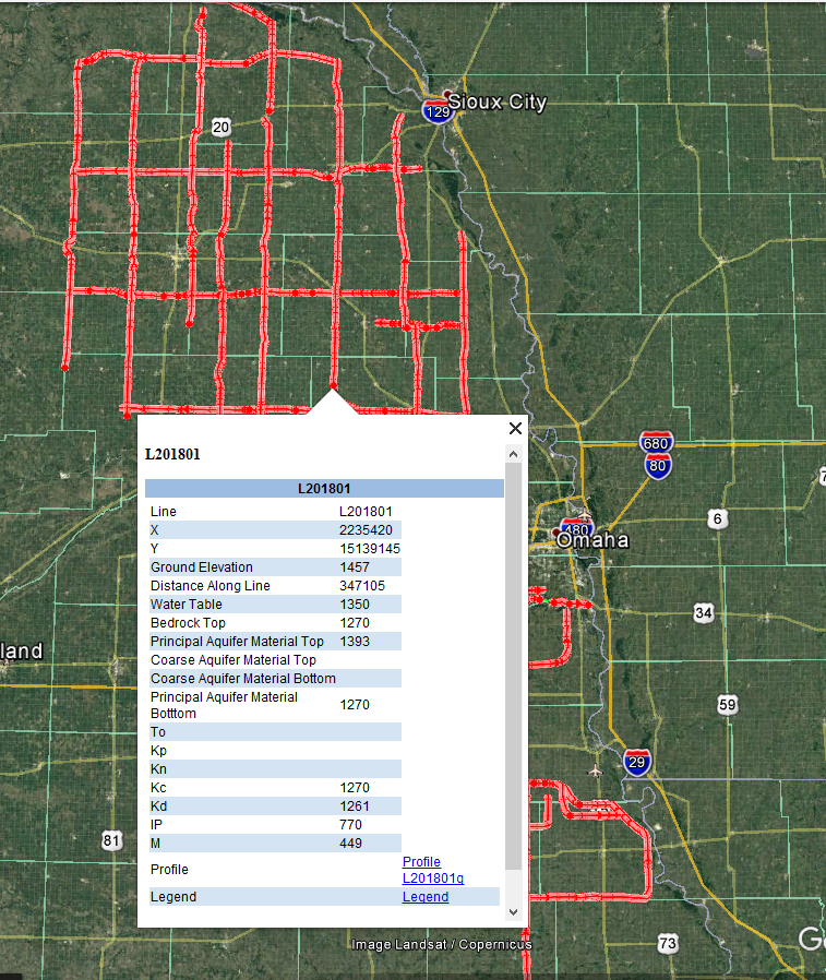
Google Earth Datasets
![]() If you already have folders named "enwra_2014" and "ENWRA_2015" on your C drive, please replace any existing .kmz files downloaded prior to April 2019. A Google Earth Pro update in early 2019 rendered the image links in the older .kmz files inoperable (impacts 2014-2015 AEM flight deliverables only).
If you already have folders named "enwra_2014" and "ENWRA_2015" on your C drive, please replace any existing .kmz files downloaded prior to April 2019. A Google Earth Pro update in early 2019 rendered the image links in the older .kmz files inoperable (impacts 2014-2015 AEM flight deliverables only).
You can download the free version of Google Earth Pro by clicking here. If you are interested in viewing the AEM datasets in Google Earth format please follow these download instructions:
STEP 1: Please create two separate folders on the C drive of your computer entitled "enwra_2014" and "ENWRA_2015" and within each of those folders create two subfolders entitled "KMZ" and "Profiles"
STEP 2: Please download the Google Earth and Microsoft Word files below. Save the Fall 2014 and Spring 2015 Flights .kmz files into the corresponding "KMZ" subfolders you created in "enwra_2014" and "ENWRA_2015" on your C drive. Save the Microsoft Word files into the corresponding "enwra_2014" and "ENWRA_2015" main folders.
![]() Fall 2014 Flights (KMZ, 1.3 MB) - repaired April 2019
Fall 2014 Flights (KMZ, 1.3 MB) - repaired April 2019
![]() Fall 2014 Legend (DOCX, 786 KB)
Fall 2014 Legend (DOCX, 786 KB)
![]() Spring 2015 Flights (KMZ, 1.0 MB) - repaired April 2019
Spring 2015 Flights (KMZ, 1.0 MB) - repaired April 2019
![]() Spring 2015 Legend (DOCX, 1.6 MB)
Spring 2015 Legend (DOCX, 1.6 MB)
STEP 3: Do the same for the PNG images provided below that you would be interested in (please refer to the flight line locations here) but put them in the corresponding "Profiles" folders of "enwra_2014" and "ENWRA_2015" on your C drive. All files must be unzipped in order to work in Google Earth.
![]() enwra_2014_all_images (116 PNGs, 93 MB)
enwra_2014_all_images (116 PNGs, 93 MB)
![]() ENWRA_2015_all_images (84 PNGs, 179 MB)
ENWRA_2015_all_images (84 PNGs, 179 MB)
STEP 4: In Google Earth, click "Tools", then "Options".
STEP 5: In the Google Earth Options box, click the "General" tab.
STEP 6: Under "Placemark balloons", make sure the box is checked to allow access to local files and personal data.
STEP 7: Under "Display", make sure the box is checked to show web results in external browser.
STEP 8: The .kmz files within the folder named "KMZ" can now be opened and viewed in Google Earth.
STEP 9: It is important to not alter the file structure or names of anything in the “enwra_2014” or "ENWRA_2015" folders.
STEP 10: If your browser defaults the kmz download to a ".txt" file, download and rename with ".kmz" at the end and it should work.
 Google Earth Tips and Tricks:
Grab the map with your cursor and hold down the "u" key on your keyboard to view the earth looking straight down instead of at an angle. Do the same and hit the "n" key to orient the map north as up.
Google Earth Pro (link above) is free and you can hit the file menu, then hit open, and then select all data import formats from the dropdown and open an ESRI shapefile or many other GIS file types in Google Earth directly from a saved location on your computer.
Google Earth Tips and Tricks:
Grab the map with your cursor and hold down the "u" key on your keyboard to view the earth looking straight down instead of at an angle. Do the same and hit the "n" key to orient the map north as up.
Google Earth Pro (link above) is free and you can hit the file menu, then hit open, and then select all data import formats from the dropdown and open an ESRI shapefile or many other GIS file types in Google Earth directly from a saved location on your computer.
Geodabase File Datasets:
![]() North Geodatabase (ZIPPED .gbd file, 11 MB)
North Geodatabase (ZIPPED .gbd file, 11 MB)
![]() South Geodatabase (ZIPPED .gbd file, 6.5 MB)
South Geodatabase (ZIPPED .gbd file, 6.5 MB)