Lower Elkhorn . Lewis & Clark . Nemaha . Papio-Missouri River . Lower Platte North . Lower Platte South
2018 Airborne Electromagnetic (AEM) Surveys
![]() The AEM data for the 2018 surveys are now available at the Nebraska GeoCloud (NGC): "https://snr.unl.edu/csd/geology/nebraskageocloud.aspx"). The NGC is a web-based digital platform for geophysical, geological, and groundwater data and models. The purpose of the NGC is to archive Nebraska’s vast volume of data and make it accessible to both model builders and model users.
The AEM data for the 2018 surveys are now available at the Nebraska GeoCloud (NGC): "https://snr.unl.edu/csd/geology/nebraskageocloud.aspx"). The NGC is a web-based digital platform for geophysical, geological, and groundwater data and models. The purpose of the NGC is to archive Nebraska’s vast volume of data and make it accessible to both model builders and model users.
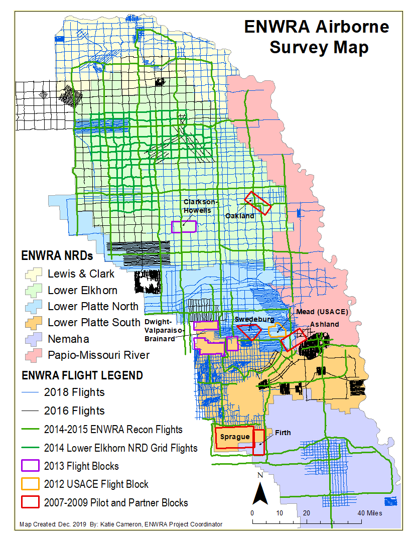
The six eastern Nebraska Natural Resources Districts (NRDs) conducted AEM flights this June through late July 2018 using Water Sustainability Fund (WSF) grant dollars awarded in November 2017 ("https://nrc.nebraska.gov/water-sustainability-fund-0").
The Lower Platte North, Lower Platte South, Papio-Missouri River, Lewis and Clark, Lower Elkhorn, and Nemaha NRDs each had a mix of the following types of surveys in eastern Nebraska:
- block flights (tightly spaced flight lines for determining aquifer boundaries and/or potential groundwater volumes)
- transect/tie line flights (longer reconnaissance type flight lines)
- grid flights (hybrid of reconnaissance and detailed type suveys, aquifer boundary mapping)
Click ![]() here (Google Earth .kmz)
here (Google Earth .kmz) ![]() or here (Shapefile Download) for links to download the 2006-2020 Existing Areas Flown using AEM survey (line renaming and duplicate removal in progress). You can also click here for an interactive map of all the Nebraska flight Lines as of Dec 2020. The Lewis and Clark NRD has a separate interactive map of 2014-2018 flight lines within 5 miles of the District available here :
or here (Shapefile Download) for links to download the 2006-2020 Existing Areas Flown using AEM survey (line renaming and duplicate removal in progress). You can also click here for an interactive map of all the Nebraska flight Lines as of Dec 2020. The Lewis and Clark NRD has a separate interactive map of 2014-2018 flight lines within 5 miles of the District available here : ![]() Shapefile Download (1.5 MB)
Shapefile Download (1.5 MB) ![]() kmz file Download (0.3 MB).
kmz file Download (0.3 MB).
The preflight work was very critical the success of the AEM survey and included the following planning activities: mapping out flight lines to avoid infrastructure and potential interferences (approximately 11,000 line kilometers/6,835 miles), equipment/personnel mobilization, helicopter fueling and ferrying logistics, background data gathering, submission of news releases to the media and general public, and contracting.
Click here for a link to Omaha KMTV Channel 3's July 2, 2018 news coverage at the Wahoo airport. Click here for video footage of the equipment in flight just outside of the Scribner airport. Click here for a link to News Channel Nebraska's July 17, 2018 news coverage at the Pender airport.
The first chapter report providing the survey results within the Lower Elkhorn NRD was completed on December 31, 2018. The remaining NRD chapter reports were delivered throughout 2019 with the final chapter report for the Lower Platte South NRD completed December 4, 2019. Download links for the NRD chapter reports are available on this page see below.
Documents
“Airborne Electromagnetic Mapping and Hydrogeologic Framework of Selected Regions of the Eastern Nebraska Water Resources Assessment Area” Chapter on the Lewis & Clark Natural Resources District.
![]() Report Text (PDF, 39.7 MB)
Report Text (PDF, 39.7 MB)
![]() Appendix 1 - 2D Profiles (12 PDFs, 818 MB)
Appendix 1 - 2D Profiles (12 PDFs, 818 MB)
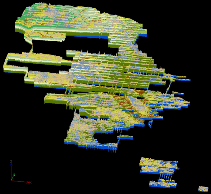
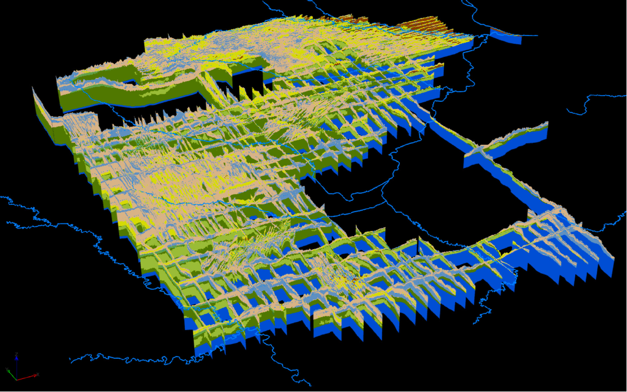
![]() Appendix 2 - 3D Images (9 PDFs, 60.3 MB)
Appendix 2 - 3D Images (9 PDFs, 60.3 MB)
![]() Appendix 3 - Data Deliverables (file types vary, 8.2 GB)
Appendix 3 - Data Deliverables (file types vary, 8.2 GB)
Datasets
Google Earth Datasets:
The interpreted results for the 2018 AEM flights have been provided in Google Earth format. You can download the free version of Google Earth Pro by clicking here.
*Click here for a link to download the Google Earth datasets from ENWRA's Dropbox.
The link above provides ".kmz" files that will show the 2018 AEM flight lines "as flown" and where data was chopped out from interferences as well as ".kmz" files that show attributed data dots in Google Earth you can click on. The attributed ".kmz" files are provided in 3 parts (broken up for faster viewing) for the 3-mile grid reconnaissance lines. There are 153 associated image files (138 MB) linked to the recon line data dots, plus 9 separate focus area ".kmz" files for the tighter spaced lines with 187 associated image files (112 MB).
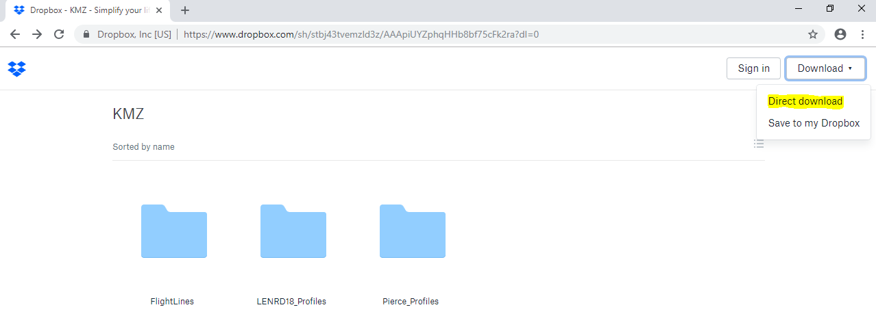
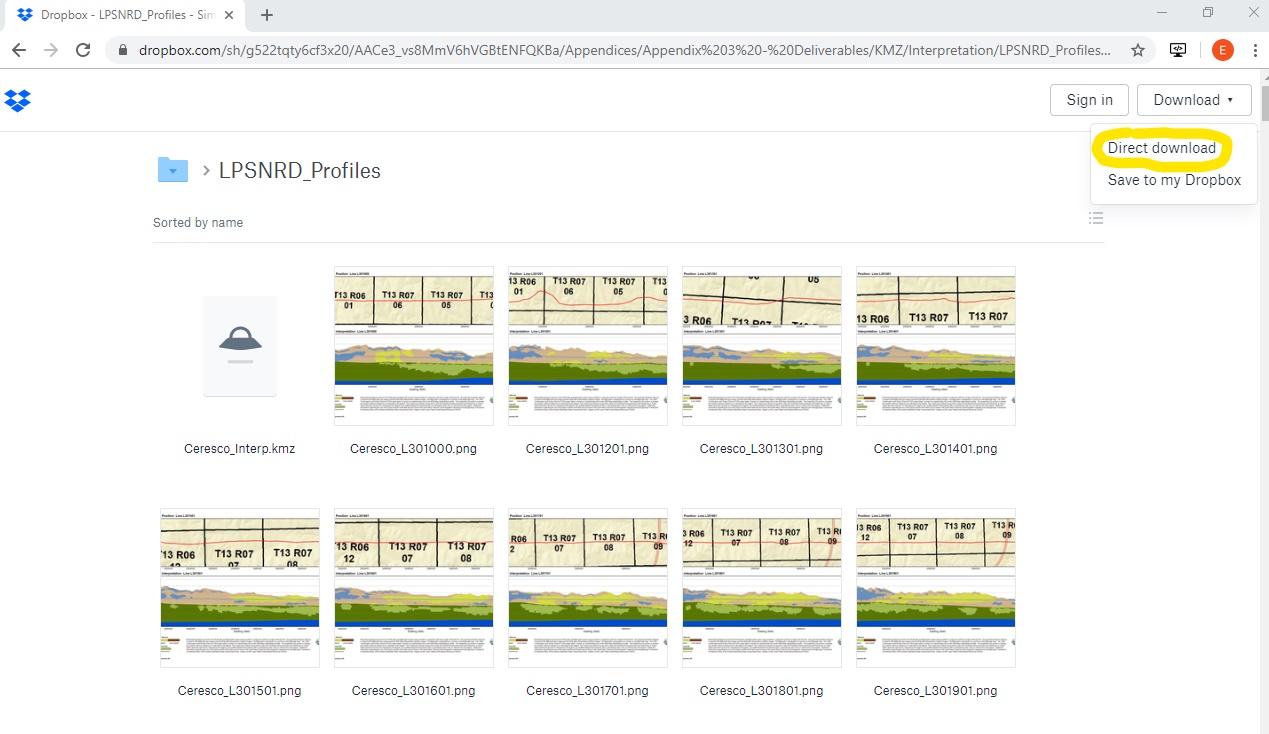
You do not need to signup or sign in to Dropbox to download the files (ENWRA Dropbox download page example shown below). You must have Google Earth installed on your computer before downloading or opening the ".kmz" Google Earth dataset files. If you already have a Dropbox account and are logged in online, please logout or choose a different browser on your computer so you do not fill up space on your personal Dropbox.
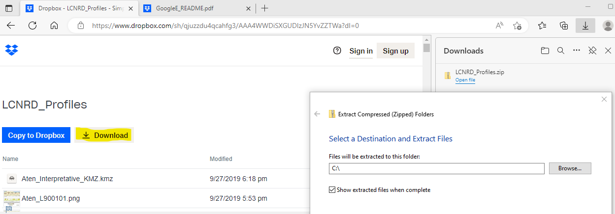
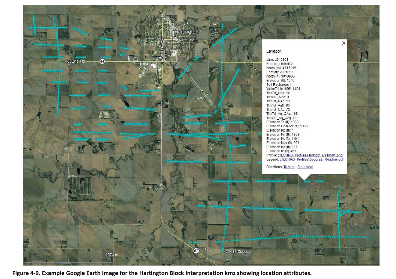
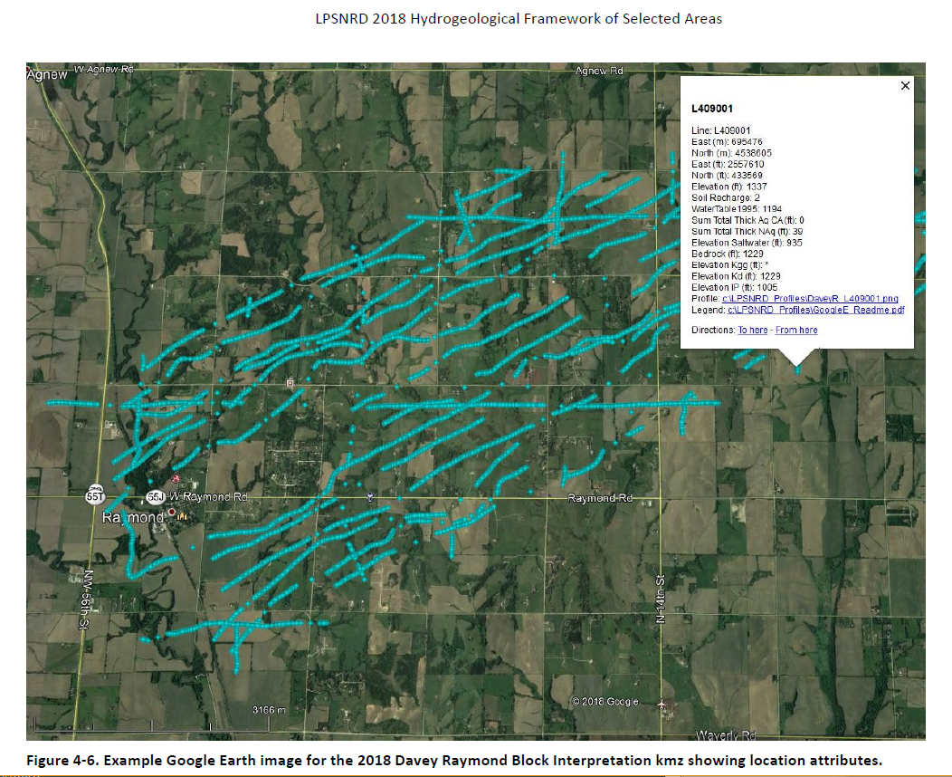
Please follow the instructions in the "GoogleE_README.pdf" PDF file on Dropbox here AND save the downloaded files with the same exact file structure as shown on the Dropbox onto your computer's C drive. Google Earth will look here on your hard drive: C:\LCNRD_Profiles\ for every profile image when you touch a link on a data dot - see example image below. An easy way to do this: hit the download button, navigate to wherever your browser typically puts downloaded files and then right click and extract the .zip file (LCNRD_Profiles.zip) directly onto your C drive. This will result in the Google Earth ".kmz" data dots linking directly to the corresponding profile image files on your C drive in the new “LCNRD_Profiles” file folder.
 NOTE: You can view flight lines from some mobile devices if you have Google Earth but you need to use a computer to see the data and hot linked profile images. Warning these Google Earth files, if downloaded, may use up to 0.5 GB of your mobile data.
Documents
“Airborne Electromagnetic Mapping and Hydrogeologic Framework of Selected Regions of the Eastern Nebraska Water Resources Assessment Area” Chapter on the Lower Elkhorn Natural Resources District.
![]() Report Text (PDF, 14 MB)
Report Text (PDF, 14 MB)
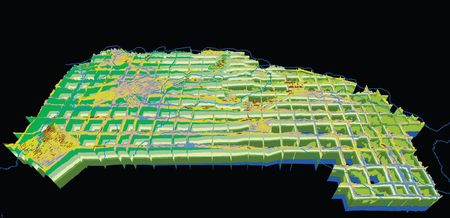
![]() Appendix 1 - 2D Profiles and Surfaces (PDF, 272 MB)
Appendix 1 - 2D Profiles and Surfaces (PDF, 272 MB)
![]() Appendix 2 - 3D Images (PDF, 24 MB)
Appendix 2 - 3D Images (PDF, 24 MB)
![]() Appendix 3 - Data Deliverables (file types vary, 6.71 GB)
Appendix 3 - Data Deliverables (file types vary, 6.71 GB)
Datasets
Google Earth Datasets:
The interpreted results for the 2018 AEM flights have been provided in Google Earth format. You can download the free version of Google Earth Pro by clicking here.
*Click here for a link to download the Google Earth datasets from ENWRA's Dropbox.
The link above provides ".kmz" files that will show the 2018 AEM flight lines "as flown" and where data was chopped out from interferences ("retained") as well as ".kmz" files that show attributed data dots in Google Earth you can click on. The attributed ".kmz" files are provided in 8 parts (broken up for faster viewing). There are 153 associated image files (300 MB) linked to the data dots, plus a separate folder for the tighter spaced lines flown in the Pierce, Nebraska area with 45 associated image files (83 MB) and a "PierceCoBlock_Interp_v5.kmz" file.
You can select "no thanks" to the sign-up for a Dropbox account and still download the files (upper right, download button shown below). You must have Google Earth installed on your computer before downloading or opening the .kmz Google Earth dataset files. If you already have a Dropbox account, please choose direct download to your computer so you do not fill up space on your personal Dropbox.
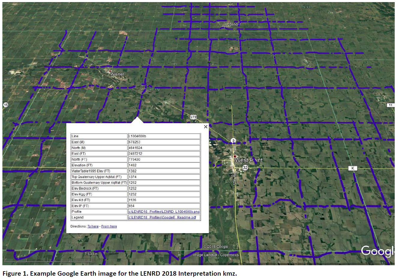
Please follow the instructions in the "GoogleE_README.pdf" PDF file on Dropbox here AND save the downloaded files with the same exact file structure as shown on the Dropbox onto your computer's C drive. Google Earth will look here on your hard drive: C:\LENRD18_Profiles\ or here: C:\Pierce_Profiles\ for every profile image when you touch a link on a data dot - see example image below. An easy way is to do this is to create folders named "LENRD18_Profiles" and/or "Pierce_Profiles" directly on your C drive, download and unzip the Dropbox files wherever your browser typically puts downloaded files, and then cut, copy or drag all the downloaded, unzipped files to those corresponding LENRD18_Profiles and Pierce_Profiles folders you created on your C drive.
 NOTE: You can view flight lines from some mobile devices if you have Google Earth but you need to use a computer to see the data and hot linked profile images. Warning these Google Earth files, if downloaded, may use up to 0.3 GB of your mobile data.
Nemaha NRD 2018 AEM Results Documents
“Airborne Electromagnetic Mapping and Hydrogeologic Framework of Selected Regions of the Eastern Nebraska Water Resources Assessment Area” Chapter on the Nemaha Natural Resources District.
 Report Text (PDF, 14 MB)
Appendix 1 - 2D Profiles and Surfaces (PDF, 70 MB)
Appendix 2 - 3D Images (PDF, 35 MB)
 Appendix 3 - Data Deliverables (file types vary, 2.25 GB)
Datasets
Google Earth Datasets:
The interpreted results for the 2018 AEM flights have been provided in Google Earth format. You can download the free version of Google Earth Pro by clicking here.
*Click here for a link to download the Google Earth datasets from ENWRA's Dropbox.
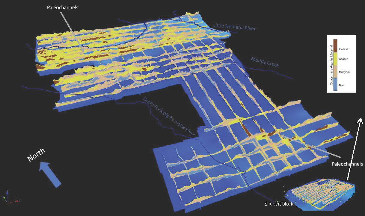
The link above provides ".kmz" files that will show the 2018 AEM flight lines "as flown" and where data was chopped out from interferences ("retained") as well as ".kmz" files that show attributed data dots in Google Earth you can click on. The attributed ".kmz" files are provided in two parts: one for the grid area flown near Tecumseh, Nebraska and a second for the block flight with tighter spaced lines around Shubert, Nebraska. There are 76 associated image files (52 MB) linked to the data dots provided in the .kmz files.
You can select "no thanks" to the sign-up for a Dropbox account and still download the files (upper right, download button shown below).
You must have Google Earth installed on your computer before downloading or opening the .kmz Google Earth dataset files. If you already have a Dropbox account, please choose direct download to your computer so you do not fill up space on your personal Dropbox.
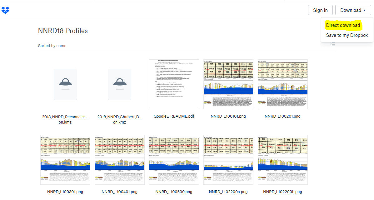
Please follow the instructions in the "GoogleE_README.pdf" PDF file on Dropbox here AND save the downloaded files with the same exact file structure as shown on the Dropbox onto your computer's C drive. Google Earth will look here on your hard drive: C:\NNRD18_Profiles for every profile image when you touch a link on a data dot - see example image below. An easy way is to do this is to select direct download at the upper right from the Dropbox link and then go unzip the Dropbox file wherever your browser typically puts downloaded files (right click and hit extract). Once the folder has been unzipped then cut, copy or drag the unzipped file folder called "NNRD18_Profiles" directly onto your C drive.
 NOTE: You can view flight lines from some mobile devices if you have Google Earth but you need to use a Microsoft Windows computer to see the data and hot linked profile images.
Papio-Missouri River NRD 2018 AEM Results Documents
“Airborne Electromagnetic Mapping and Hydrogeologic Framework of Selected Regions of the Eastern Nebraska Water Resources Assessment Area” Chapter on the Papio-Missouri River Natural Resources District
Report Text (PDF, 12 MB)
Appendix 1 - 2D Profiles (PDF, 26 MB)
Appendix 2 - 3D Images (PDF, 10 MB)
Appendix 3 - Data Deliverables (file types vary, 4.62 GB)
Datasets
Google Earth Datasets:
The interpreted results for the 2018 AEM flights have been provided in Google Earth format. You can download the free version of Google Earth Pro by clicking here.
*Click here for a link to download the Google Earth datasets from ENWRA's Dropbox.
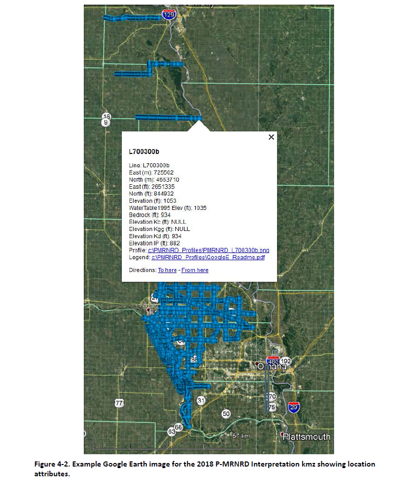
The link above provides ".kmz" files that will show the 2018 AEM flight lines "as flown" and where data was chopped out from interferences ("retained") as well as ".kmz" files that show attributed data dots in Google Earth you can click on. The attributed ".kmz" files are provided for the grid-style lines flown across the District and for the block flight with tighter spaced lines around the Tekamah, Nebraska area. There are 118 associated image files (75 MB) linked to the data dots provided in the .kmz files.
You can select "no thanks" to the sign-up for a Dropbox account and still download the files (upper right, download button shown below).
You must have Google Earth installed on your computer before downloading or opening the .kmz Google Earth dataset files. If you already have a Dropbox account, please choose direct download to your computer so you do not fill up space on your personal Dropbox.
Please follow the instructions in the "GoogleE_README.pdf" PDF file on Dropbox here AND save the downloaded files with the same exact file structure as shown on the Dropbox onto your computer's C drive. Google Earth will look here on your hard drive: C:\PMRNRD_Profiles for every profile image when you touch a link on a data dot - see example image below. An easy way is to do this is to select direct download at the upper right from the Dropbox link and then go unzip the Dropbox file wherever your browser typically puts downloaded files (right click and hit extract). Once the folder has been unzipped then cut, copy or drag the unzipped file folder called "PMRNRD_Profiles" directly onto your C drive.
 NOTE: You can view flight lines from some mobile devices if you have Google Earth but you need to use a Microsoft Windows computer to see the data and hot linked profile images.
Lower Platte North NRD 2018 AEM Results Documents
“Airborne Electromagnetic Mapping and Hydrogeologic Framework of Selected Regions of the Eastern Nebraska Water Resources Assessment Area” Chapter on the Lower Platte North Natural Resources District, v.3
Report Text (PDF, 36 MB)
Appendix 1 - 2D Profiles (PDF, 121 MB)
Appendix 2 - 3D Images (PDF, 32 MB)
Appendix 3 - Data Deliverables (file types vary, 11 GB)
Datasets
Google Earth Datasets:
The interpreted results for the 2018 AEM flights have been provided in Google Earth format. You can download the free version of Google Earth Pro by clicking here.
*Click here for a link to download the Google Earth datasets from ENWRA's Dropbox.
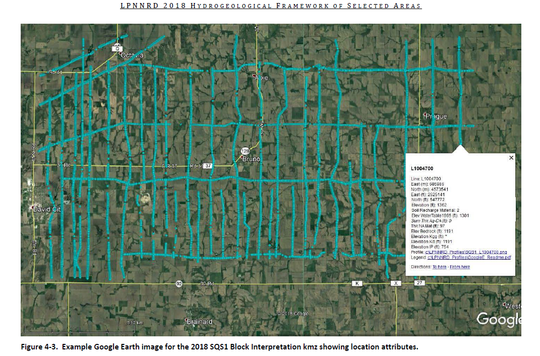
The link above provides ".kmz" files that will show the 2018 AEM flight lines "as flown" and where data was chopped out from interferences "retained" as well as ".kmz" files that show attributed data dots in Google Earth you can click on. The attributed ".kmz" files with data dots are provided in 9 parts (recon lines and separate block areas broken up for faster viewing). There are 468 associated image files (342 MB) linked to the data dots.
You can select "no thanks" to the sign-up for a Dropbox account and still download the files (upper right, download button shown below).
You must have Google Earth installed on your computer before downloading or opening the .kmz Google Earth dataset files. If you already have a Dropbox account, please choose direct download to your computer so you do not fill up space on your personal Dropbox.
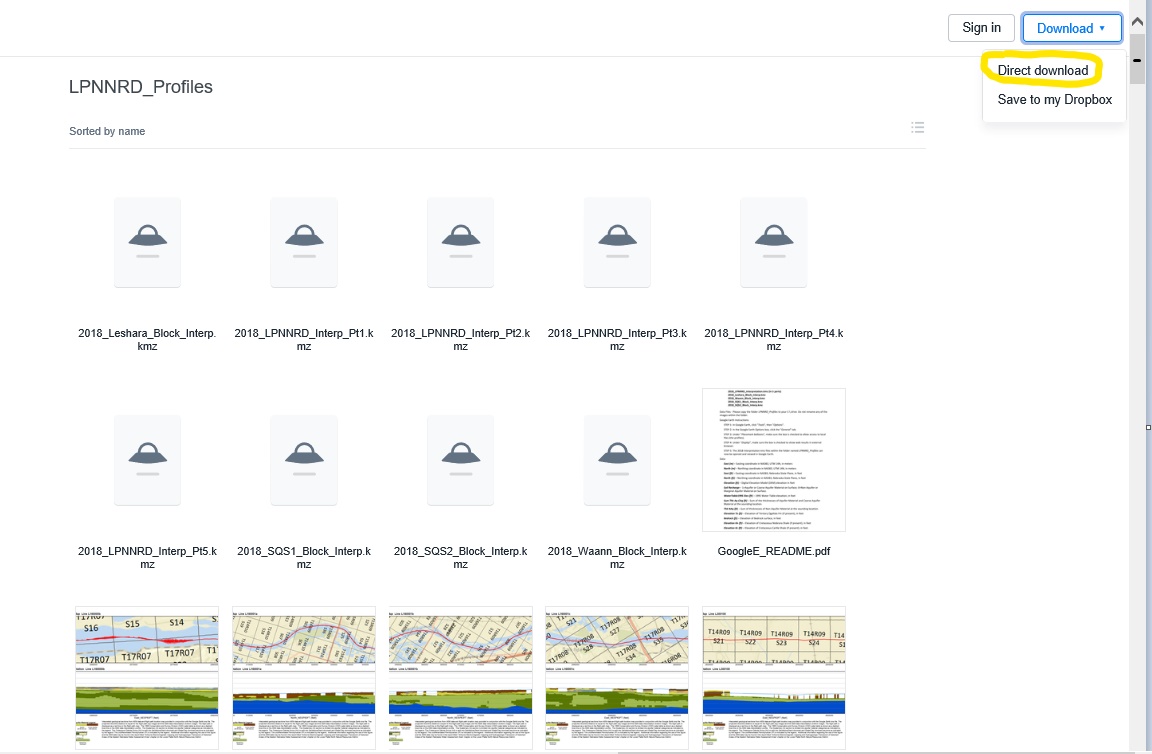
Please follow the instructions in the "GoogleE_README.pdf" PDF file on Dropbox here AND save the downloaded files with the same exact file structure as shown on the Dropbox onto your computer's C drive. Google Earth will look here on your hard drive: C:\LPNNRD_Profiles\ for every profile image when you touch a link on a data dot - see example image below. An easy way is to download and unzip the Dropbox files wherever your browser typically puts downloaded files (right click and hit extract). Once the folder has been unzipped then cut, copy or drag the unzipped file folder called "LPNNRD_Profiles" directly onto your C drive.
 NOTE: You can view flight lines from some mobile devices if you have Google Earth but you need to use a computer to see the data and hot linked profile images. Warning these Google Earth files, if downloaded, may use up a large portion of your mobile data.
Lower Platte South NRD 2018 AEM Results Documents
“Airborne Electromagnetic Mapping and Hydrogeologic Framework of Selected Regions of the Eastern Nebraska Water Resources Assessment Area” Chapter on the Lower Platte South Natural Resources District
Report Text (PDF, 158 MB)
Appendix 1 - 2D Profiles (PDF, 154 MB)
Appendix 2 - 3D Images (PDF, 54 MB)
Appendix 3 - Data Deliverables (file types vary, 8.3 GB)
Datasets
Google Earth Datasets:
The interpreted results for the 2018 AEM flights have been provided in Google Earth format. You can download the free version of Google Earth Pro by clicking here.
*Click here for a link to download the Google Earth datasets from ENWRA's Dropbox.
The link above provides ".kmz" files that will show the 2018 AEM flight lines (as flown) and where data was chopped out from interferences (retained) as well as ".kmz" files that show attributed data dots in Google Earth you can click on. The attributed ".kmz" files with data dots are provided in 10 parts (4 recon line sets broken up for faster viewing and 6 separate block areas). There are 486 associated image files (347 MB) linked to the data dots.
You can select "no thanks" to the sign-up for a Dropbox account and still download the files (upper right, download button shown below).
You must have Google Earth installed on your computer before downloading or opening the .kmz Google Earth dataset files. If you already have a Dropbox account, please choose direct download to your computer so you do not fill up space on your personal Dropbox.
Please follow the instructions in the "GoogleE_README.pdf" PDF file on Dropbox here AND save the downloaded files with the same exact file structure as shown on the Dropbox onto your computer's C drive. Google Earth will look here on your hard drive: C:\LPSNRD_Profiles\ for every profile image when you touch a link on a data dot - see example image below. An easy way is to download and unzip the Dropbox files wherever your browser typically puts downloaded files (right click and hit extract). Once the folder has been unzipped then cut, copy or drag the unzipped file folder called "LPSNRD_Profiles" directly onto your C drive. Note if you have the 2016 AEM profiles already on your computer you will need to keep that and insert the contents into that existing folder (can't have 2 folders with the same name directly on your C drive).
 NOTE: You can view flight lines from some mobile devices if you have Google Earth but you need to use a computer to see the data and hot linked profile images. Warning these Google Earth files, if downloaded, may use up a large portion of your mobile data.
Documents
“Airborne Electromagnetic Mapping and Hydrogeologic Framework of Selected Regions of the Eastern Nebraska Water Resources Assessment Area” Chapter on the Nemaha Natural Resources District.
![]() Report Text (PDF, 14 MB)
Report Text (PDF, 14 MB)
![]() Appendix 1 - 2D Profiles and Surfaces (PDF, 70 MB)
Appendix 1 - 2D Profiles and Surfaces (PDF, 70 MB)
![]() Appendix 2 - 3D Images (PDF, 35 MB)
Appendix 2 - 3D Images (PDF, 35 MB)
![]() Appendix 3 - Data Deliverables (file types vary, 2.25 GB)
Appendix 3 - Data Deliverables (file types vary, 2.25 GB)
Datasets
Google Earth Datasets:
The interpreted results for the 2018 AEM flights have been provided in Google Earth format. You can download the free version of Google Earth Pro by clicking here.
*Click here for a link to download the Google Earth datasets from ENWRA's Dropbox.
The link above provides ".kmz" files that will show the 2018 AEM flight lines "as flown" and where data was chopped out from interferences ("retained") as well as ".kmz" files that show attributed data dots in Google Earth you can click on. The attributed ".kmz" files are provided in two parts: one for the grid area flown near Tecumseh, Nebraska and a second for the block flight with tighter spaced lines around Shubert, Nebraska. There are 76 associated image files (52 MB) linked to the data dots provided in the .kmz files.
You can select "no thanks" to the sign-up for a Dropbox account and still download the files (upper right, download button shown below). You must have Google Earth installed on your computer before downloading or opening the .kmz Google Earth dataset files. If you already have a Dropbox account, please choose direct download to your computer so you do not fill up space on your personal Dropbox.
Please follow the instructions in the "GoogleE_README.pdf" PDF file on Dropbox here AND save the downloaded files with the same exact file structure as shown on the Dropbox onto your computer's C drive. Google Earth will look here on your hard drive: C:\NNRD18_Profiles for every profile image when you touch a link on a data dot - see example image below. An easy way is to do this is to select direct download at the upper right from the Dropbox link and then go unzip the Dropbox file wherever your browser typically puts downloaded files (right click and hit extract). Once the folder has been unzipped then cut, copy or drag the unzipped file folder called "NNRD18_Profiles" directly onto your C drive.
NOTE: You can view flight lines from some mobile devices if you have Google Earth but you need to use a Microsoft Windows computer to see the data and hot linked profile images.
Papio-Missouri River NRD 2018 AEM Results Documents
“Airborne Electromagnetic Mapping and Hydrogeologic Framework of Selected Regions of the Eastern Nebraska Water Resources Assessment Area” Chapter on the Papio-Missouri River Natural Resources District
Report Text (PDF, 12 MB)
Appendix 1 - 2D Profiles (PDF, 26 MB)
Appendix 2 - 3D Images (PDF, 10 MB)
Appendix 3 - Data Deliverables (file types vary, 4.62 GB)
Datasets
Google Earth Datasets:
The interpreted results for the 2018 AEM flights have been provided in Google Earth format. You can download the free version of Google Earth Pro by clicking here.
*Click here for a link to download the Google Earth datasets from ENWRA's Dropbox.
The link above provides ".kmz" files that will show the 2018 AEM flight lines "as flown" and where data was chopped out from interferences ("retained") as well as ".kmz" files that show attributed data dots in Google Earth you can click on. The attributed ".kmz" files are provided for the grid-style lines flown across the District and for the block flight with tighter spaced lines around the Tekamah, Nebraska area. There are 118 associated image files (75 MB) linked to the data dots provided in the .kmz files.
You can select "no thanks" to the sign-up for a Dropbox account and still download the files (upper right, download button shown below).
You must have Google Earth installed on your computer before downloading or opening the .kmz Google Earth dataset files. If you already have a Dropbox account, please choose direct download to your computer so you do not fill up space on your personal Dropbox.
Please follow the instructions in the "GoogleE_README.pdf" PDF file on Dropbox here AND save the downloaded files with the same exact file structure as shown on the Dropbox onto your computer's C drive. Google Earth will look here on your hard drive: C:\PMRNRD_Profiles for every profile image when you touch a link on a data dot - see example image below. An easy way is to do this is to select direct download at the upper right from the Dropbox link and then go unzip the Dropbox file wherever your browser typically puts downloaded files (right click and hit extract). Once the folder has been unzipped then cut, copy or drag the unzipped file folder called "PMRNRD_Profiles" directly onto your C drive.
NOTE: You can view flight lines from some mobile devices if you have Google Earth but you need to use a Microsoft Windows computer to see the data and hot linked profile images.
Lower Platte North NRD 2018 AEM Results Documents
“Airborne Electromagnetic Mapping and Hydrogeologic Framework of Selected Regions of the Eastern Nebraska Water Resources Assessment Area” Chapter on the Lower Platte North Natural Resources District, v.3
Report Text (PDF, 36 MB)
Appendix 1 - 2D Profiles (PDF, 121 MB)
Appendix 2 - 3D Images (PDF, 32 MB)
Appendix 3 - Data Deliverables (file types vary, 11 GB)
Datasets
Google Earth Datasets:
The interpreted results for the 2018 AEM flights have been provided in Google Earth format. You can download the free version of Google Earth Pro by clicking here.
*Click here for a link to download the Google Earth datasets from ENWRA's Dropbox.
The link above provides ".kmz" files that will show the 2018 AEM flight lines "as flown" and where data was chopped out from interferences "retained" as well as ".kmz" files that show attributed data dots in Google Earth you can click on. The attributed ".kmz" files with data dots are provided in 9 parts (recon lines and separate block areas broken up for faster viewing). There are 468 associated image files (342 MB) linked to the data dots.
You can select "no thanks" to the sign-up for a Dropbox account and still download the files (upper right, download button shown below).
You must have Google Earth installed on your computer before downloading or opening the .kmz Google Earth dataset files. If you already have a Dropbox account, please choose direct download to your computer so you do not fill up space on your personal Dropbox.
Please follow the instructions in the "GoogleE_README.pdf" PDF file on Dropbox here AND save the downloaded files with the same exact file structure as shown on the Dropbox onto your computer's C drive. Google Earth will look here on your hard drive: C:\LPNNRD_Profiles\ for every profile image when you touch a link on a data dot - see example image below. An easy way is to download and unzip the Dropbox files wherever your browser typically puts downloaded files (right click and hit extract). Once the folder has been unzipped then cut, copy or drag the unzipped file folder called "LPNNRD_Profiles" directly onto your C drive.
NOTE: You can view flight lines from some mobile devices if you have Google Earth but you need to use a computer to see the data and hot linked profile images. Warning these Google Earth files, if downloaded, may use up a large portion of your mobile data.
Lower Platte South NRD 2018 AEM Results Documents
“Airborne Electromagnetic Mapping and Hydrogeologic Framework of Selected Regions of the Eastern Nebraska Water Resources Assessment Area” Chapter on the Lower Platte South Natural Resources District
Report Text (PDF, 158 MB)
Appendix 1 - 2D Profiles (PDF, 154 MB)
Appendix 2 - 3D Images (PDF, 54 MB)
Appendix 3 - Data Deliverables (file types vary, 8.3 GB)
Datasets
Google Earth Datasets:
The interpreted results for the 2018 AEM flights have been provided in Google Earth format. You can download the free version of Google Earth Pro by clicking here.
*Click here for a link to download the Google Earth datasets from ENWRA's Dropbox.
The link above provides ".kmz" files that will show the 2018 AEM flight lines (as flown) and where data was chopped out from interferences (retained) as well as ".kmz" files that show attributed data dots in Google Earth you can click on. The attributed ".kmz" files with data dots are provided in 10 parts (4 recon line sets broken up for faster viewing and 6 separate block areas). There are 486 associated image files (347 MB) linked to the data dots.
You can select "no thanks" to the sign-up for a Dropbox account and still download the files (upper right, download button shown below).
You must have Google Earth installed on your computer before downloading or opening the .kmz Google Earth dataset files. If you already have a Dropbox account, please choose direct download to your computer so you do not fill up space on your personal Dropbox.
Please follow the instructions in the "GoogleE_README.pdf" PDF file on Dropbox here AND save the downloaded files with the same exact file structure as shown on the Dropbox onto your computer's C drive. Google Earth will look here on your hard drive: C:\LPSNRD_Profiles\ for every profile image when you touch a link on a data dot - see example image below. An easy way is to download and unzip the Dropbox files wherever your browser typically puts downloaded files (right click and hit extract). Once the folder has been unzipped then cut, copy or drag the unzipped file folder called "LPSNRD_Profiles" directly onto your C drive. Note if you have the 2016 AEM profiles already on your computer you will need to keep that and insert the contents into that existing folder (can't have 2 folders with the same name directly on your C drive).
NOTE: You can view flight lines from some mobile devices if you have Google Earth but you need to use a computer to see the data and hot linked profile images. Warning these Google Earth files, if downloaded, may use up a large portion of your mobile data.
Documents
“Airborne Electromagnetic Mapping and Hydrogeologic Framework of Selected Regions of the Eastern Nebraska Water Resources Assessment Area” Chapter on the Papio-Missouri River Natural Resources District
![]() Report Text (PDF, 12 MB)
Report Text (PDF, 12 MB)
![]() Appendix 1 - 2D Profiles (PDF, 26 MB)
Appendix 1 - 2D Profiles (PDF, 26 MB)
![]() Appendix 2 - 3D Images (PDF, 10 MB)
Appendix 2 - 3D Images (PDF, 10 MB)
![]() Appendix 3 - Data Deliverables (file types vary, 4.62 GB)
Appendix 3 - Data Deliverables (file types vary, 4.62 GB)
Datasets
Google Earth Datasets:
The interpreted results for the 2018 AEM flights have been provided in Google Earth format. You can download the free version of Google Earth Pro by clicking here.
*Click here for a link to download the Google Earth datasets from ENWRA's Dropbox.
The link above provides ".kmz" files that will show the 2018 AEM flight lines "as flown" and where data was chopped out from interferences ("retained") as well as ".kmz" files that show attributed data dots in Google Earth you can click on. The attributed ".kmz" files are provided for the grid-style lines flown across the District and for the block flight with tighter spaced lines around the Tekamah, Nebraska area. There are 118 associated image files (75 MB) linked to the data dots provided in the .kmz files.
You can select "no thanks" to the sign-up for a Dropbox account and still download the files (upper right, download button shown below). You must have Google Earth installed on your computer before downloading or opening the .kmz Google Earth dataset files. If you already have a Dropbox account, please choose direct download to your computer so you do not fill up space on your personal Dropbox.
Please follow the instructions in the "GoogleE_README.pdf" PDF file on Dropbox here AND save the downloaded files with the same exact file structure as shown on the Dropbox onto your computer's C drive. Google Earth will look here on your hard drive: C:\PMRNRD_Profiles for every profile image when you touch a link on a data dot - see example image below. An easy way is to do this is to select direct download at the upper right from the Dropbox link and then go unzip the Dropbox file wherever your browser typically puts downloaded files (right click and hit extract). Once the folder has been unzipped then cut, copy or drag the unzipped file folder called "PMRNRD_Profiles" directly onto your C drive.
NOTE: You can view flight lines from some mobile devices if you have Google Earth but you need to use a Microsoft Windows computer to see the data and hot linked profile images.
Documents
“Airborne Electromagnetic Mapping and Hydrogeologic Framework of Selected Regions of the Eastern Nebraska Water Resources Assessment Area” Chapter on the Lower Platte North Natural Resources District, v.3
![]() Report Text (PDF, 36 MB)
Report Text (PDF, 36 MB)
![]() Appendix 1 - 2D Profiles (PDF, 121 MB)
Appendix 1 - 2D Profiles (PDF, 121 MB)
![]() Appendix 2 - 3D Images (PDF, 32 MB)
Appendix 2 - 3D Images (PDF, 32 MB)
![]() Appendix 3 - Data Deliverables (file types vary, 11 GB)
Appendix 3 - Data Deliverables (file types vary, 11 GB)
Datasets
Google Earth Datasets:
The interpreted results for the 2018 AEM flights have been provided in Google Earth format. You can download the free version of Google Earth Pro by clicking here.
*Click here for a link to download the Google Earth datasets from ENWRA's Dropbox.
The link above provides ".kmz" files that will show the 2018 AEM flight lines "as flown" and where data was chopped out from interferences "retained" as well as ".kmz" files that show attributed data dots in Google Earth you can click on. The attributed ".kmz" files with data dots are provided in 9 parts (recon lines and separate block areas broken up for faster viewing). There are 468 associated image files (342 MB) linked to the data dots.
You can select "no thanks" to the sign-up for a Dropbox account and still download the files (upper right, download button shown below). You must have Google Earth installed on your computer before downloading or opening the .kmz Google Earth dataset files. If you already have a Dropbox account, please choose direct download to your computer so you do not fill up space on your personal Dropbox.
Please follow the instructions in the "GoogleE_README.pdf" PDF file on Dropbox here AND save the downloaded files with the same exact file structure as shown on the Dropbox onto your computer's C drive. Google Earth will look here on your hard drive: C:\LPNNRD_Profiles\ for every profile image when you touch a link on a data dot - see example image below. An easy way is to download and unzip the Dropbox files wherever your browser typically puts downloaded files (right click and hit extract). Once the folder has been unzipped then cut, copy or drag the unzipped file folder called "LPNNRD_Profiles" directly onto your C drive.
NOTE: You can view flight lines from some mobile devices if you have Google Earth but you need to use a computer to see the data and hot linked profile images. Warning these Google Earth files, if downloaded, may use up a large portion of your mobile data.
Documents
“Airborne Electromagnetic Mapping and Hydrogeologic Framework of Selected Regions of the Eastern Nebraska Water Resources Assessment Area” Chapter on the Lower Platte South Natural Resources District
![]() Report Text (PDF, 158 MB)
Report Text (PDF, 158 MB)
![]() Appendix 1 - 2D Profiles (PDF, 154 MB)
Appendix 1 - 2D Profiles (PDF, 154 MB)
![]() Appendix 2 - 3D Images (PDF, 54 MB)
Appendix 2 - 3D Images (PDF, 54 MB)
![]() Appendix 3 - Data Deliverables (file types vary, 8.3 GB)
Appendix 3 - Data Deliverables (file types vary, 8.3 GB)
Datasets
Google Earth Datasets:
The interpreted results for the 2018 AEM flights have been provided in Google Earth format. You can download the free version of Google Earth Pro by clicking here.
*Click here for a link to download the Google Earth datasets from ENWRA's Dropbox.
The link above provides ".kmz" files that will show the 2018 AEM flight lines (as flown) and where data was chopped out from interferences (retained) as well as ".kmz" files that show attributed data dots in Google Earth you can click on. The attributed ".kmz" files with data dots are provided in 10 parts (4 recon line sets broken up for faster viewing and 6 separate block areas). There are 486 associated image files (347 MB) linked to the data dots.
You can select "no thanks" to the sign-up for a Dropbox account and still download the files (upper right, download button shown below). You must have Google Earth installed on your computer before downloading or opening the .kmz Google Earth dataset files. If you already have a Dropbox account, please choose direct download to your computer so you do not fill up space on your personal Dropbox.
Please follow the instructions in the "GoogleE_README.pdf" PDF file on Dropbox here AND save the downloaded files with the same exact file structure as shown on the Dropbox onto your computer's C drive. Google Earth will look here on your hard drive: C:\LPSNRD_Profiles\ for every profile image when you touch a link on a data dot - see example image below. An easy way is to download and unzip the Dropbox files wherever your browser typically puts downloaded files (right click and hit extract). Once the folder has been unzipped then cut, copy or drag the unzipped file folder called "LPSNRD_Profiles" directly onto your C drive. Note if you have the 2016 AEM profiles already on your computer you will need to keep that and insert the contents into that existing folder (can't have 2 folders with the same name directly on your C drive).
NOTE: You can view flight lines from some mobile devices if you have Google Earth but you need to use a computer to see the data and hot linked profile images. Warning these Google Earth files, if downloaded, may use up a large portion of your mobile data.